
C.Bhoobun1*, F.Grasso2 , R.Verney3
1,2,3 IFREMER : French national institute for ocean science and technology, France
* Corresponding author: cbhoobun@ifremer.fr
Introduction
In the context of climate change and increasing anthropogenic pressures, coastal systems are experiencing shifts in the frequency and intensity of hazards. These areas are often densely populated and economically important, making them more vulnerable to environmental changes. Intertidal mudflats, which are vital but fragile coastal habitats, play an essential role in both ecological functionalities and geomorphological processes. Tidal courses within these mudflats, including channels and creeks, are crucial for water and sediment exchange, contributing to mudflat stability. Due to their dynamic nature, understanding how the morphology of these tidal courses relates to physical mudflat characteristics is essential.
Objective and Methods
The objective of our study is to quantify key morphological features of tidal courses, such as width, depth, and rhythmicity, and correlate these features with mudflat characteristics to better understand the relationship between tidal courses and mudflat dynamics.
To achieve this, we developed an automated toolbox for quantifying tidal course morphology using LiDAR-based Digital Elevation Models (DEMs). This toolbox automatically detects and measures key features, such as the depth and width of the tidal courses. It starts by extracting cross-sectional profiles along both the x-axis and y-axis from the DEMs and identifying changes in elevation to determine the edges and calculate the width and depth of the tidal courses. The data from both directions are then integrated to provide a comprehensive distribution of the courses’ morphological features.
Results
The toolbox provided results on the tidal course locations, depths and widths associated with the mudflat slope (e.g., for a Seine Estuary mudflat in Figure 1). Further application to other intertidal areas revealed significant variability in tidal course distributions. Tidal course depths were notably lower within constrained intertidal areas (e.g., elevated mudflats with embankments), whereas the tidal courses were deeper in wider mudflats (e.g., at the mouth of the Seine Estuary, France). Moreover, tidal course dimensions were related to the mudflat morphology, with the largest courses (i.e., deeper and wider) occurring near the tidal flat slope break. Hence, the developed toolbox provides a generic method to investigate the interaction between tidal courses and mudflat morphologies.
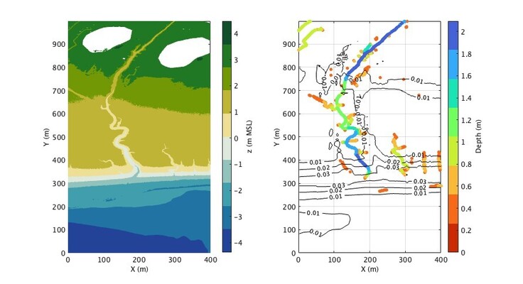
Figure 1: Mudflat elevation z, relative to mean sea level MSL (left), and tidal course depth (> 0.4 m, colour dots) and mudflat slope (black iso-lines) (right), at the mouth of the Seine Estuary, France.
References
- Grasso, F., and Le Hir, P., (2019), Influence of morphological changes on suspended sediment dynamics in a macrotidal estuary: Diachronic analysis in the Seine Estuary (France) from 1960 to 2010. Ocean Dynamics, 69(1), 83–100.
- Hanssen, J.L.J., van Prooijen, B.C., Volp, N.D., de Vet, P.L.M., and Herman, P.M.J., (2022), Where and why do creeks evolve on fringing and bare tidal flats? Geomorphology, 403, 108182.