J.M. van der Meer1,*, J. de Smit1, J. van Belzen2,3 & T. Terpstra1
1HZ University of Applied Sciences, Middelburg, 2NIOZ - Royal Netherlands Institute for Sea Research, Yerseke, 3Wageningen Marine Research, Yerseke
*Corresponding author: j.m.van.der.meer@hz.nl
Introduction
Sea level rise requires adaptation measures to prevent the land from flooding and mitigate the damage once a flood occurs. The traditional approach of raising the primary dyke structures comes with serious disadvantages. Apart from the increasing costs this will bring, a higher dyke reduces only the probability of a flood, but not the consequences. Simulations show that for 1 meter SLR in the Western Scheldt, flood damage will be much wider spread, and also the mortality rate increases at least tenfold compared to the current situation. This poses a serious challenge in maintaining regulatory safety standards.
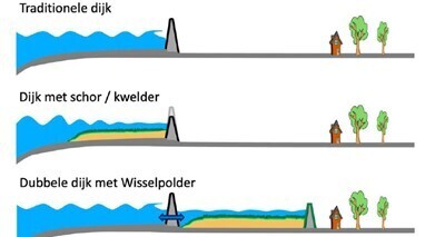
Adaptation measures should therefore aim at reducing both flood risk and flood consequences. And example of such a measure is promoting foreland establishment e.g. via the establishment of a double dyke system (van Belzen et al., 2021, Figure 1). In the Western Scheldt, due to it’s high suspended sediment concentration, this will cause the land to increase rapidly in height by sedimentation and vegetation, leading to a salt marsh with natural channels and mudflats (Weisscher et al. 2022). For the implementation of a transitional polder as part of coastal defence, we need to know 1) how such a system will develop, and 2) how it affects dyke breach scenario’s.
Objective and Methods
In order to model the flooding risk for different sea-level rise scenarios we use the newest flooding models in Delft3D FM Suite 1D2D in combination with a 2D model for tidal flat & salt marsh dynamics (SFERE, van de Vijsel et al., 2023), for which we adapt the sediment and vegetation term to describe the development of the new marsh under varying SLR rates and suspended sediment concentrations. The second model is based on the shallow water equations and can quickly model the gully formation patterns and sedimentation height in the coming decades, under influence of vegetation. The model is applied specifically to the 30-3 dyke trajectory in Zak van Zuid-Beveland. We will validate this model by comparing the result to existing salt marshes and channels in the Western Scheldt. The novelty of the described method lies in the combination of flooding models with the modelling of growing salt marshes.
Results
Preliminary results show that transitional polders significantly reduce the damage of flooding under sea level rise, due to a shallower dyke break and less water intruding the land.

Figure 1, cross-sections comparing a dyke, dyke with foreland, and transitional polder (van Belzen et al., 2021).
References
van Belzen, J., Rienstra, G., & Bouma, T. (2021). Dubbele dijken als robuuste waterkerende landschappen voor een welvarende Zuidwestelijke Delta. NIOZ Koninklijk Nederlands Instituut voor Onderzoek der Zee.
Van de Vijsel, R. C., van Belzen, J., Bouma, T. J., van der Wal, D., Borsje, B. W., Temmerman, S., ... & van de Koppel, J. (2023). Vegetation controls on channel network complexity in coastal wetlands. Nature communications, 14(1), 7158.
Weisscher, S. A., Baar, A. W., Van Belzen, J., Bouma, T. J., & Kleinhans, M. G. (2022). Transitional polders along estuaries: Driving land-level rise and reducing flood propagation. Nature-Based Solutions, 2, 100022.


