
R. Hulskamp1*, M. Pregnolato1 , S. De Vries1
1 Delft University of Technology, Netherlands
* Corresponding author: r.l.hulskamp@tudelft.nl
Introduction
Coastal dunes are dynamic ecosystems that provide critical services such as flood protection, habitat provision, and recreational opportunities, while contributing to climate resilience. However, these systems are increasingly threatened by climate change, sea-level rise, and intensifying human activities, leading to coastal squeeze [1, 2]. Coastal squeeze restricts the natural adaptation of dunes and hinders coastal ecosystems from fulfilling their critical services. An option to mitigate the effects of coastal squeeze can be by creating seaward space through artificial beach widening.
This study focuses on the Zandmotor [3], a mega-nourishment project initiated in 2011 near The Hague, The Netherlands, as a case study for creating new coastal space and as a model for sustainable coastal management. The Zandmotor has expanded beaches, fostered biodiversity, and provided valuable recreational space. Despite these successes, the long-term evolution of its landscape, particularly the interaction between sedimentation and vegetation dynamics and dune development, remains underexplored. This study investigates the processes driving dune development at the Zandmotor, focusing on the interplay of sediment accretion and vegetation establishment. By using remote sensing data, this research aims to deepen understanding of how engineered landscapes can stimulate dune growth, offering insights into sustainable coastal management and adaptation strategies for mitigating climate-driven threats.
Objective and Methods
This study investigates how new dunes develop at the Zandmotor through interactions between vegetation establishment and sedimentation dynamics. We focus on the evolution of a flat, barren sandy surface into significant dune structures.
To achieve these objectives, cross-shore transects spaced 100 meters apart were created over the Zandmotor area. Elevation data was analysed and extracted along these transects using bi-annually collected digital terrain models (DTMs) that are publicly available. Bi-annual dune volumes were calculated by integrating the elevation profiles and a linear trend was fitted through the volumes over time, that represents the volume change per alongshore meter per year of the transect. Vegetation presence was assessed using publicly available RGB aerial photographs converted to greyscale and classified, while distinguishing vegetated areas from sandy surfaces (with Otsu’s method [5]). By combining dune elevation and volume changes with vegetation distribution data, this study identifies key interactions between sediment and vegetation, offering a detailed understanding of the processes driving dune formation and the role of engineered landscapes in enhancing coastal resilience.
Results
The study highlights significant dune growth at the Zandmotor, driven by sediment dynamics and vegetation development. Initially, sedimentation was concentrated near the existing dune (x = 40 m), with a new foredune forming during the project's early years (see Fig. 1). From 2017 onward, sediment deposition expanded seaward (x = 150–300 m). Analysis of cross-shore transects revealed predominantly accretive processes.
Dune volume increased (surprisingly) linearly, with an initial growth rate of 15 m³/m/year (R² = 0.90) prior to vegetation establishment. After vegetation began developing in 2016, the growth rate accelerated to 53 m³/m/year (R² = 0.99). Vegetation thrived around elevation peaks (see Fig. 1), playing a crucial role in sediment trapping and amplifying dune volume increases. Although vegetation generally persisted and expanded, occasional losses were observed.
These findings underscore the vegetation’s critical role in enhancing dune volume and coastal resilience [6, 7, 8], aligning with broader coastal trends [4]. The Zandmotor demonstrates how engineered landscapes may foster resilient ecosystems, support biodiversity, and promote sustainable coastal management. This research is a first step of integrating ecosystems and biodiversity to build adaptive landscapes, mitigate climate-related disasters, and address challenges such as sea-level rise and coastal squeeze, offering insights into nature-based solutions for climate adaptation.
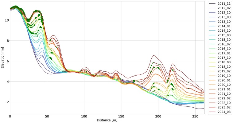
Fig. 1. Transect profile: cross-shore distance on the x-axis (0 m is bicycle lane, right is the seaward side), elevation in meters on the y-axis. Coloured lines represent profiles of different years. Green dots represent the presence of vegetation, extracted from RGB images. The larger the dot the higher percentage of vegetation per m2. Note that vegetation data is only present for the following timestamps (year_month): 2016_02, 2017_01, 2018_03, 2019_02, 2020_01, 2022_02, 2023_02.
References
- Silva, R., Martínez, M., van Tussenbroek, B., Guzmán-Rodriguez, L., Mendoza, E., and López-Portillo, J., (2020), A Framework to Manage Coastal Squeeze. Sustainability 12(24), 1-21.
- Lansu, E., Reijers, V., Höfer, S., Luijendijk, A., Rietkerk, M., Wassen, M., Lammerts, E., and van der Heide, T., (2024), A global analysis of how human infrastructure squeezes sandy coasts. Nature Communications 15(1), 432.
- M, de Schipper, M., Luijendijk A., Aarninkhof, S., van Gelder-Maas C., van Thiel de Vries, J., de Vries, S., Henriquez, M., Marx, S., and Ranasinghe, R., (2013), A New Alternative to Saving Our Beaches from Sea-Level Rise: The Sand Engine. Journal of Coastal Research 29(5), 1001-1008.
- De Vries, S., Southgate, H., Kanning, W., and Ranasinghe, R., (2012), Dune behaviour and aeolian transport on decadal timescales. Coastal Engineering 67, 41-53.
- Otsu, N., (1979), A Threshold Selection Method from Gray-Level Histograms. IEEE Transac-tions on Systems, Man, and Cybernetics 1, 62-66.
- Maun, M., (1998), Adaptations of plants to burial in coastal sand dunes. Canadian Journal of Botany 76(5), 713-738.
- Keijsers, J., de Groot, A., and Riksen, M., (2015), Vegetation and sedimentation on coastal foredunes. Geomorphology 228, 723-734.
- Nolet, C., van Puijenbroek, M., Suomalainen, J., Limpens, J., and Riksen, M., (2018), UAV-imaging to model growth response of marram grass to sand burial: Implications for coastal dune development. Aeolian Research 31, 50-61.