
D.C. Hulskemper1*, R. Hulskamp1, T. Dewez2, J.A.Á. Antolínez1, R.C. Lindenbergh
1 Delft University of Technology, The Netherlands; 2 BRGM: French geological survey, France
* Corresponding author: d.c.hulskemper@tudelft.nl
Introduction
The morphology of sandy coastal systems is extremely dynamic with separate constituents like dunes, bars, and berms shifting in shape, position, and volume. Apart from these larger entities, smaller morphologies, like embryo dunes can exist, which can be transient, persistent, or show spatiotemporal variations in orientation, size, and shape (Montreuil et al., 2013, Van Puijenbroek et al., 2017). Understanding their three-dimensional dynamics requires tracking their movement and morphological evolution over time.
The topography of embryonic dune fields can be captured in high detail using Unoccupied Aerial Vehicle (UAV) based LiDAR measurements. Through comparison of repeated measurements at different epochs, their dynamics can then be studied. However, with a larger number of epochs, manual investigation becomes impractical, necessitating automated methods.
Current automated methods for extracting morphological changes often assume a Eulerian approach (e.g., Kuschnerus et al., 2024), meaning change is defined as displacement of the surface at one point in space. While appropriate for mass balance assessments, specific landform dynamics escape these methods as the captured feature is time series of elevation change rather than geomorphic characteristics evolution.
Objective and Methods
The objective of this study is to develop a method for extracting the extent and characteristics of individual embryo dunes from point clouds and tracking their evolution over time using a Lagrangian approach. This allows for the identification of transport direction and morphological changes.
To achieve this, we apply the Medial Axis Transform (MAT; Ma et al., 2012; Peters & Ledoux, 2016) to extract “skeletons” of dunes, i.e., their mathematical internal and external surfaces. Several properties can be derived from these MAT surfaces, including ridge lines, dune feet, and overall dune extents. To obtain the extent of each dune, we first cluster the internal MAT points using DBSCAN, ensuring that each cluster represents a single embryo dune. Next, we delineate the outline of each cluster by fitting an alpha shape around the points used to construct the MAT.
The MAT is applied to a dataset of five consecutive UAV LiDAR point clouds acquired between February and October 2024 as part of an ongoing measurement campaign. The area under consideration in this study is an embryo dune field at the Zandmotor, The Netherlands (52°02'40"N 4°10'50"E).
Results
Figure 1A shows the derived outlines and projected internal MAT surface of part of the embryo dune field. Over time, dune outlines change from elongated to compact and rounded, while their number increases. Figure 1B presents a zoomed-in view of the black-boxed area in Figure 1A. The ridge line of the orange dune changes shape after the first epoch and later bifurcates. Figure 1C shows the orientation distribution of the MAT surfaces. In the first epoch, most dunes are orientated northeast. Over time, their orientations become more evenly distributed between 315° and 135°, reflecting the observations in Figure 1A. This suggests a shift in dominant transport directions, potentially influenced by external environmental forces.
The results demonstrate that the MAT can effectively extract representative dune extents and track their morphological evolution. Future research will explore how these changes correlate with environmental conditions like predominant wind direction, intensity, and vegetation characteristics. Further steps in the research also includes the temporal matching of identified dune extents, considering their potential merging, splitting and movement.
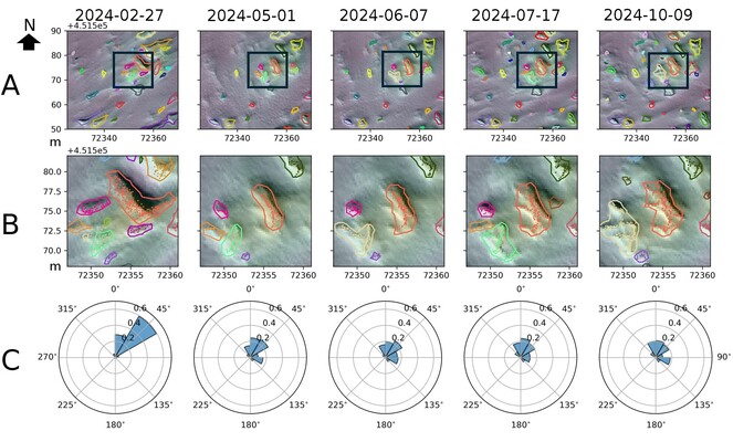
Figure 1: A) Spatial extent of different dunes, automatically extracted through the Medial Axis Transform (MAT). B) Zoom on black box of A. Here the planar projection of the internal MAT is shown for each extracted dune. C) Distribution of orientation of the internal MAT of the dunes.
References
Kuschnerus, Mieke, Sierd De Vries, José A. Á. Antolínez, Sander Vos, and Roderik Lindenbergh. “Identifying Topographic Changes at the Beach Using Multiple Years of Permanent Laser Scanning.” Coastal Engineering 193 (October 2024): 104594. https://doi.org/10.1016/j.coastaleng.2024.104594.
Ma, Jaehwan, Sang Won Bae, and Sunghee Choi. “3D Medial Axis Point Approximation Using Nearest Neighbors and the Normal Field.” The Visual Computer 28, no. 1 (January 2012): 7–19. https://doi.org/10.1007/s00371-011-0594-7.
Montreuil, Anne‐Lise, Joanna E. Bullard, Jim H. Chandler, and Jon Millett. ‘Decadal and Seasonal Development of Embryo Dunes on an Accreting Macrotidal Beach: North Lincolnshire, UK’. Earth Surface Processes and Landforms 38, no. 15 (December 2013): 1851–68. https://doi.org/10.1002/esp.3432.
Peters, Ravi, and Hugo Ledoux. “Robust Approximation of the Medial Axis Transform of LiDAR Point Clouds as a Tool for Visualisation.” Computers & Geosciences 90 (May 2016): 123–33. https://doi.org/10.1016/j.cageo.2016.02.019.
Van Puijenbroek, Marinka E.B., Juul Limpens, Alma V. De Groot, Michel J.P.M. Riksen, Maurits Gleichman, Pieter A. Slim, Han F. Van Dobben, and Frank Berendse. ‘Embryo Dune Development Drivers: Beach Morphology, Growing Season Precipitation, and Storms’. Earth Surface Processes and Landforms 42, no. 11 (15 September 2017): 1733–44. https://doi.org/10.1002/esp.4144.