Wietse van de Lageweg1,*, Eric van Zanten2, Jaco de Smit1 & Chiu Cheng1
1HZ University of Applied Sciences, Middelburg, 2Rijkswaterstaat, Zee & Delta, Middelburg
* *Corresponding author: wietse.van.de.lageweg@hz.nl
Introduction
A water-level rise of lake Veere is inevitable in the longer term (>25 years) due to a rise of the water level in the Eastern Scheldt. Currently, the shallow lakeshore zone is predominantly (~90%) protected by hard shore protection with no natural ability to adapt to a higher water level. Indeed, topographical analyses indicate that multiple outer dike will be flooded immediately if a higher water level of only 10 cm would be set with serious implications for (holiday) homes, recreational activities and ecological functioning.
Nature-based measures provide a promising path towards the future shores of lake Veere to strengthen its natural functioning as well as providing a more flexible management tool. Softer and natural shores already exist in a limited number of more sheltered locations, including Goudplaat (i.e. undefended where erosion is prevented by a breakwater in the foreshore), Haringvreter (pioneer salt marsh and mudflats where waves break and erosion is limited) and Schelphoek (artificial sandy beach with a gentle foreshore to dampen wave attack). Yet, to assess the feasibility of upscaling these softer natural shores to other location a good understanding of the hydrodynamics of the shallow zone of the lake is required to inform decisions about the future shore management.
Objective and Methods
A monitoring campaign was carried out from July-December 2024 to measure currents and waves in the lake. Applied sensors include three Nortek ECO ADCPs (see https://eco.nortekgroup.com/) and three Ocean Sensor Systems (OSSI-010-003B/C) wave gauges positioned at the various depths on the shallow shores of Schotsman and Oostwatering in the western part of lake Veere. The monitoring campaign was aligned with ADCP measurements in the deeper parts of lake Veere in the context of the StratiFest project aimed at unravelling stratification patterns.
Results
Preliminary analyses suggest a strong wind-driven wave and current climate with wind-direction representing the strongest link with wave/current speeds and directions. At 10 m depth, peak flow velocities reached 0.19 m/s whereas closer to the shore a velocity of 0.5 m/s was reached during the strongest wind event. A maximum significant wave height of 0.4 m was recorded at the exposed Schotsman shores. The collected wave and current data provides new insights into wind-driven larger-scale circulation patterns from deeper to shallower shores that may hold important clues to better understand the ongoing stratification issues as well as the feasibility of more nature-based future lake shores.
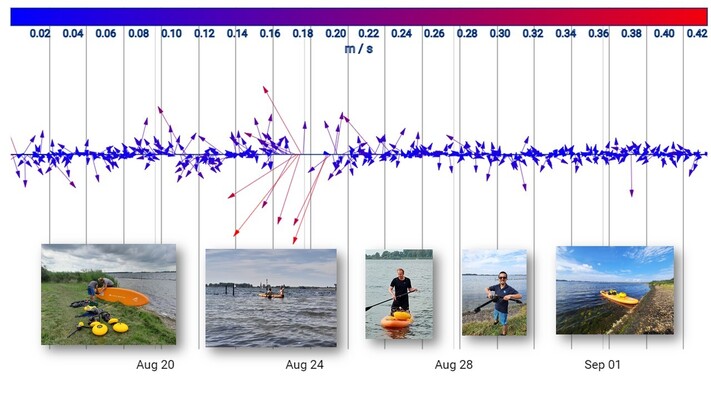
Deployment of Eco-ADCPs in lake Veere to monitor current dynamics from deeper to shallower shores.