
T. Jonathans1*, A.J.F. Hoitink1 , A.D. Ashton 2, R.C. van de Vijsel1
1 Wageningen University, The Netherlands; 2 Woods Hole Oceanographic Institution, USA
* Corresponding author: terra.jonathans@wur.nl
Introduction
Tidal marshes have a crucial role in coastal protection, habitat provision and carbon sequestration. The ability to recover after a large disturbance, the ecosystem’s resilience, is key for maintaining a healthy marsh ecosystem. However, accelerating sea-level rise and subsidence reduce resilience, potentially causing the marsh to collapse. To prevent marshes from collapsing, understanding marsh resilience and its recovery process after a large disturbance is essential. Recovery time is defined as the duration required for vegetation to regrow after a disturbance. A large recovery time may indicate reduced resilience, making it a potential early warning indicator for marsh degradation.
Objective and Methods
This study aims to quantify the recovery time of tidal marshes after Hurricane Katrina in the Mississippi Delta in 2005, using remote sensing data. This is done by using NDVI time series acquired from Landsat 5 images to estimate the recovery time of marshes with approximately 400 m resolution covering an area of 1260 km2. These recovery times are then analysed and compared with bed elevation data from LIDAR data (OCM Partners, 2025). The quality of our analyses is assessed by comparing areas with estimated large recovery times with areas of observed marsh loss, as provided by Murray et al. (2022).
Results
Preliminary results show large spatial variability in recovery time across the marsh (Figure 1). No clear correlation with bed elevation is found, suggesting that other environmental factors are important in determining marsh resilience. Ongoing analyses explore such additional factors and evaluate their applicability as early warning indicators of marsh loss. These indicators can serve as a guideline to inform landscape managers to most effectively apply marsh protection strategies.
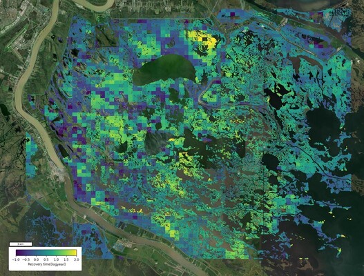
Figure 1. Recovery time of tidal marshes after Hurricane Katrina. Recovery time is derived from NDVI time series (Landsat 5). The represented recovery time shows large spatial variability within the area of interest.
References
Murray, N.J., Worthington, T.A., Bunting, P., Duce, S., Hagger, V., Lovelock, C.E., Lucas, R., Saunders, M.I., Sheaves, M., Spalding, M. and Waltham, N.J., (2022). High-resolution mapping of losses and gains of Earth’s tidal wetlands. Science, 376(6594), pp.744-749.
OCM Partners, (2025): 2021 USGS Lidar: Coastal Louisiana from 2021-03-04 to 2021-11-23. NOAA National Centers for Environmental Information, https://www.fisheries.noaa.gov/inport/item/72308.
