
M.E.B. van Puijenbroek1*, M. Bolding1 , M. Baptist1, K. Elschot1,2
1 Wageningen Marine Research, Wageningen University and Research, The Netherlands; 2 Wageningen Environmental Research, Wageningen University and Research, The Netherlands
* Corresponding author: marinka.vanpuijenbroek@wur.nl
Introduction
Saltmarshes are vital ecosystems that provide multiple ecosystem services such as habitat for specific plants and birds, coastal protection and carbon storage. However, they are vulnerable to rising sea levels. Salt marshes may gradually drown if sedimentation cannot keep pace with rising sea levels. The response of salt marsh vegetation to such drowning remains uncertain, yet is crucial for understanding salt marsh resilience.
Objective and Methods
We compared the vegetation development of two back-barrier salt marshes: Oost-Ameland en Schiermonnikoog. On Oost-Ameland, deep soil subsidence due to gas extraction has occurred, and sedimentation has partly been insufficient to compensate for it. Both study sites have areas that are grazed by cattle and areas that remain ungrazed, allowing us to compare their vegetation development. Vegetation changes were assessed using Rijkswaterstaat vegetation maps over a 25-year period.
Results
The island experiencing deep soil subsidence had more vegetation regression to an earlier succession stage than the island without subsidence. The high salt marsh vegetation transitioned to a lower salt marsh vegetation and bare patches increased. Additionally, vegetation regression occurred more in grazed areas with soil subsidence, suggesting that grazing reduces salt marsh resilience to sea level rise.
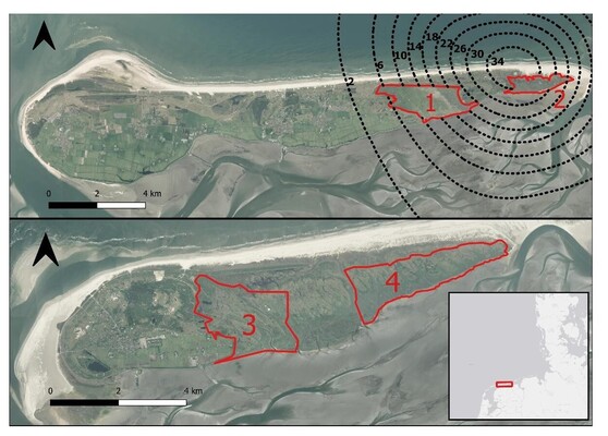
Aerial image of the two study sites: Ameland and Schiermonnikoog. Top: Ameland with grazed marsh Neerlands Reid (1) and ungrazed marsh De Hon (2). Bottom: Schiermonnikoog with the grazed marsh (3) and the ungrazed marsh with an similar age to the De Hon (4). The red lined areas are our study sites. The dotted black lines indicate the deep soil subsidence in cm (NAM, 2022).