
H. Shafiei1*, S.G. Pearson1, A.J.H.M. Reniers1
1 Delft University of Technology, Department of Hydraulic Engineering, Delft, 2600GA, The Netherlands.
* Corresponding author: h.shafiei@tudelft.nl
Introduction
Sandy coasts are highly dynamic environments where hydrodynamic forcings drive sediments in varied directions through time and space. Therefore, analysing the resultant large number of particle trajectories is challenging. Coastal sediment connectivity is a newly-developed framework which takes advantage of techniques from network science to systematically investigate the dynamics of sediment pathways [1,2]. One of the main initial steps to analyse sediment connectivity is to establish the structure of its complex network. This step enables us not only to illustrate the sediment pathways in a quantifiable manner but also to calculate the relevant local and global network metrics.
Objective and Methods
The sediment pathways are obtained using the particle-tracking model SedTRAILS (Sediment TRAnsport vIsualization & Lagrangian Simulator) which is the core of the coastal connectivity framework. Particles in SedTRAILS are transported using hydrodynamics derived from an Eulerian model (here, the Delft3D model of Reniers et al. [3]). To mitigate the effects of lateral boundaries, only the central part of the surf zone is seeded with particles. The equations of Soulsby et al. [4] are then used to convert flow velocities and bed shear stresses to effective particle velocities. These particle velocities are then used to propagate the sediments along a fixed bed. The initial spatial configuration of the seeded particles is used to create polygons centered around each particle. These polygons are connected according to the trajectory and residence time of the particles passing through them. Consequently, it is possible to obtain the structure of the sediment connectivity network by considering the number, strength, and direction of the connections between the polygons. Furthermore, morphodynamic simulations of Delft3D can be used to define new input bathymetries for SedTRAILS at regular intervals. In this way, the temporal evolution of the network structure can be investigated.
Results
The strongest velocity is offshore directed and occurs on the sea side of the bar at around 800<y<1000 m (Figure 1(a)). This is the location where the main channel is eventually excavated in the morphodynamic model (not shown in this abstract). Figure 1(b) shows the movement of the seeded particles in the first 30 minutes of SedTRAILS simulation. The color of each particle gets lighter as they age during the simulation. It is observed that the particles over the bar travel the longest path, and the convergence of particles emerges around the downstream of the strongest undertow. Furthermore, the resultant network of sediment pathways is structured as in Figure 1(c). The network shows spatially coherent patterns corresponding to rip currents and eddies. Once in this format, the network can be further analyzed to quantify the interconnected sediment pathways. For example, we will be able to identify the spatial distribution of main sediment sinks and sources; furthermore, patterns of sediment collection and spreading will be explored.
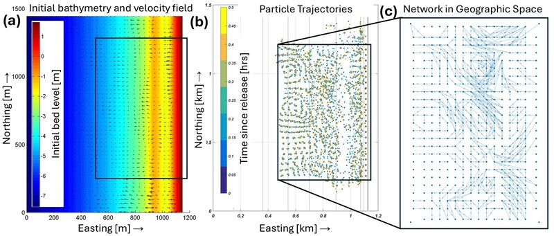
Figure (1). Simulation results (The black solid rectangle highlights the section chosen to be the SedTRAILS domain). (a) morphostatic Delft3D results - initial bathymetry and velocity field used as inputs of SedTRAILS. (b) SedTRAILS results – evolution of the positions of the particles from their initial configuration (blue) to final state (after 30 minutes; yellow). (c) SedTRAILS results - the resultant sediment connectivity network in geographic space with uniform resolution of 40 meters.
References
- Pearson, S. G., Elias, E. P. L., van Ormondt, M., Roelvink, F. E., Lambregts, P. M., Wang, Z., & van Prooijen, B. Lagrangian sediment transport modelling as a tool for investigating coastal connectivity. In , Coastal Dynamics Conf (2021).
- Pearson, S. G., van Prooijen, B. C., Elias, E. P., Vitousek, S., & Wang, Z. B. Sediment connectivity: A framework for analyzing coastal sediment transport pathways. Journal of Geophysical Research: Earth Surface, 125(10), e2020JF005595 (2020).
- Reniers, A. J., Roelvink, J. A., & Thornton, E. B. Morphodynamic modeling of an embayed beach under wave group forcing. Journal of Geophysical Research: Oceans, 109(C1) (2004).
- Soulsby, R. L., Mead, C. T., Wild, B. R., & Wood, M. J. Lagrangian model for simulating the dispersal of sand-sized particles in coastal waters. Journal of waterway, port, coastal, and ocean engineering, 137(3), 123-131 (2011).