S.J. Baltussen1*, E.W. Nota1 , M.G. Kleinhans1
1 Utrecht University, the Netherlands
* Corresponding author: s.j.baltussen@students.uu.nl
Introduction
The Nieuwe Waterweg is a heavily engineered estuary that forms the mouth of the Rhine and Meuse rivers and the entrance to the Port of Rotterdam. To accommodate increasingly larger ships to the harbours, the Nieuwe Waterweg has been narrowed, straightened and embanked, and the bed is continuously dredged to an unnaturally deep water depth (currently -16m NAP) (Cox et al., 2022). This has led to increased flood risks, salinity intrusion and ecosystem degradation in the area and these issues are expected to worsen with climate change-induced sea-level rise and more frequent storms and low river discharges. Historically, flood safety has been ensured with hard engineering solutions, such as dikes and the Maeslantkering storm surge barrier. However, salinity intrusion and ecological loss are no longer acceptable as trade-offs for the economic benefits of harbour development. An alternative, nature-based solution to counteract these issues was proposed by Meyer et al. (2021): stop dredging and allow natural sedimentation processes to make the channel shallower again. However, the morphological responses under these natural sedimentation conditions are unknown due to the unnatural planform shape of the estuary. This knowledge gap is addressed here by scale experimentation (graduation research project of Baltussen, 2025).
Objective and Methods
Our objective is to provide an imaginary of a future where natural sedimentation processes are given free range and gain insight into the ensuing sedimentation-erosion patterns. The morphological development of the Nieuwe Waterweg without dredging was simulated in physical scale experiments in the Metronome tidal facility at Utrecht University (www.uu.nl/metronome). The Metronome is a 20 by 3 m flume, that periodically tilts on its short axis to generate reversing tidal flows capable of sediment transport, which leads to the formation of dynamic estuarine morphology (Kleinhans et al., 2017). The tilting was asymmetrical to create initial flood dominant conditions as present in reality, and has a period of 40 s and amplitude <0.1 m. Three experiments were conducted: a control experiment with a straight channel with fixed banks, representing the Nieuwe Waterweg, and sand only, an experiment with the addition of a harbour complex, representing the Botlek and Third Petroleum Harbour, and an experiment with the same set-up plus mud supply (crushed nutshell) at the river boundary. The development of the sedimentation-erosion patterns over 10,000 tidal cycles was captured by overhead photography and measured with laser scans of the dry bed.
Results
Due to the fixed planform shape, the morphology in the experiments developed a converging shape in the vertical instead of the horizontal as in natural estuaries. This resulted in a pattern of increasing landward shallowing by net sedimentation and seaward deepening by net erosion in all experiments (see the figure). In the experiments with the harbour complex, the larger tidal prism resulted in more landward sedimentation, especially with mud supply. The harbour complex itself acted as a sediment trap in both experiments, also with most sedimentation with mud supply. In general, the mud deposited mostly in inactive areas, on top of bars and in the landward end of the estuary. For the Nieuwe Waterweg, the same general pattern of landward shallowing and seaward deepening is expected to develop. However, due to the large water depth in the Nieuwe Waterweg, this is expected to develop by increasing amounts of landward sedimentation only. This development would have large consequences for the accessibility for ships and thus the harbour industry. However, shallowing would also counteract saline intrusion, decrease flood risks and provide new areas for nature restoration which could turn the harbour areas into new attractive living and working spaces.
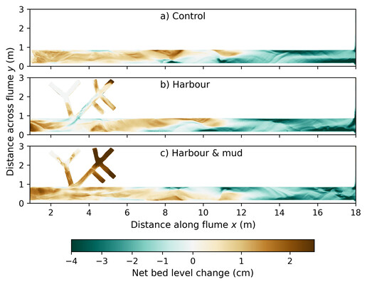
Total bed level change after 6000 tidal cycles, relative to the initial bed level elevation (0 cycles) for the a) control, b) harbour and c) harbour & mud experiment. Positive values correspond to sedimentation, negative values to erosion.
References
Baltussen, S. J. (2025). An experimental study of the natural sedimentation-erosion patterns in the Nieuwe Waterweg. (Master’s thesis, Utrecht University). Retrieved from https://studenttheses.uu.nl/handle/20.500.12932/48402
Cox, J. R., Leuven, J. R. F. W., Pierik, H. J., van Egmond, M., & Kleinhans, M. G. (2022). Sediment deficit and morphological change of the rhine–meuse river mouth attributed to multi-millennial anthropogenic impacts. Continental Shelf Research, 244, 104766. doi: 10.1016/j.csr.2022.104766
Kleinhans, M. G., van der Vegt, M., Leuven, J. R. F. W., Braat, L., Markies, H., Simmelink, A., . . . van Maarseveen, M. (2017). Turning the tide: comparison of tidal flow by periodic sea level fluctuation and by periodic bed tilting in scaled landscape experiments of estuaries. Earth Surface Dynamics, 5(4), 731–756. doi: 10.5194/esurf-5-731-2017
Meyer, H., Blom, E., ARK Natuurontwikkeling, WWR & Bureau Stroming. (2021). Rijnmonding als estuarium (Tech. Rep.). The Netherlands: Deltaprogramma. https://www.deltaprogramma.nl/binaries/deltacommissaris/ documenten/publicaties/2021/03/03/rijnmonding-als-estuarium/Rijnmonding+ als+estuarium.pdf. (Accessed: 2025-01-24)