W. Ridderinkhof1*, T. Nieuwhuis1 , E. Elias2
1 Witteveen+Bos, Netherlands; 2 Deltares, Netherlands
* Corresponding author: wim.ridderinkhof@witteveenbos.com
Introduction
The southwestern coast of Texel is influenced by sediment bypassing that leads to the formation of shoals on the ebb-tidal delta. These shoals migrate towards the coast, acting as a natural supply of sediments. Both subtidal and supratidal shoals attach to the coast with different intervals. Periods between the large supratidal shoals exceed centuries. The repetitive attachment of shoals and associated channel migration results in a varying beach width, and thereby to a dynamic dune evolution.
Human interventions have also impacted the natural dynamics of this area. The closure of the Zuiderzee led to large-scale reshaping of channels and shoals on the ebb-tidal delta. Along the coastline, the construction of a groin field (1959-1987) reduced the coastal retreat. The nourishment program that has maintained the coastline since 1993 resulted in an additional sediment supply of 180,000 m³/year.
Current beach management presents several challenges. The nourishment program is demanding, requiring interventions every 3-4 years. The nourishments result in higher, more uniform primary dunes that hinder sand flux to the landward nature area, causing unnatural aging of vegetation and reduced biodiversity. Additionally, the beach width is sometimes too narrow for recreational and military use. Finally, sea level rise places pressure on the flood safety.
Objective and Methods
Six alternative coastal management strategies were investigated on behalf of Province Noord Holland, Municipality Texel, Hoogheemraadschap Hollands Noorderwartier, Rijkswaterstaat, Staatsbosbeheer and the Ministry of Defense to resolve the present-day and future challanges. The coastal management alternatives were evaluated on the themes: Nature, Water, Use, Landscape, Sustainability, and Costs.
This evaluation was performed for the present-state coastal system and for future conditions. Evaluation of future conditions was made using morphological projections have been made for the expected state of the alternatives and reference situation in 2050 and in 2100. The following components were considered: beach width, the surface area of various natural habitats (e.g. dune valleys, embryonic dunes, white dunes, grey dunes), the sand flux towards the nature area, the required nourishment volumes to maintain the coastline. This was done based on literature, conceptual reasoning, and available observations.
Results
Morphologic projections for 2050 and 2100 have been elaborated to such a level of detail that it became possible to carry out the impact assessment and identify relevant differences in the effects of the various alternatives. For this, a sea level rise of 0.38 m in 2050 and 1.24 m in 2100 is assumed (the upper boundary of the high CO2 emissions climate scenario obtained from the KNMI '23 climate scenarios).
For all variants, the morphological expectations have been elaborated to such a level of detail that it became possible to carry out the impact assessment and identify relevant differences in the effects of the various variants. Specifically, we have developed projections for (1) the effect of migration shoals on the morphological developments in the coming decades; (2) the effect of sea level rise on the required nourishment volumes at a beach that is protected by groins; (3) the effect of blowouts and dune notches on dune volume and sand fluxes to the nature areas.
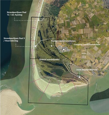
Project area southwest Texel
References
Elias E., van der Spek A.J.F., Morfologische ontwikkeling van De Hors – Texel. Deltares rapport 11204540-000-ZKS-0007, 2020.
Rakhorst, H.D., 1984, Werking strandhoofden Noord-Holland, Texel, Vlieland, Rijkswaterstaat, adviesdienst Hoorn, Nota WWKZ84.H007, 15 pag., 16 bijlagen.
Quataert, E., Elias, E. (2022). Verkenning probleemlocaties kust. Morfologische karakterisering en verwachte suppletie inspanning komende 50 jaar voor 4 probleemlocaties. Deltares, 11208035‑001‑ZKS‑0001.
