
T. Leijnse1,2*, J. Aerts1,2 , S. Muis1,2, A. van Dongeren2,3
1 Vrije Universiteit Amsterdam, Netherlands; 2 Deltares, Netherlands; 3 IHE Delft, Netherlands
* Corresponding author: Tim.Leijnse@deltares.nl
Introduction
Coastal communities worldwide are under threat of flooding due to a combination of tide, surge, rivers, rain and waves. However, for coastal flooding assessments at regional to continental scales, waves are often not or only by approximation accounted for due to the high computational expense needed of numerical models. While the physics of wave-driven flooding is already included in the fast flood model SFINCS (Leijnse et al., 2021), boundary conditions to drive SFINCS were in the past still needed from a computationally expensive numerical model like XBeach (Roelvink et al., 2009), or from 1D based (meta) models (McCall et al., 2024). To truly make use of SFINCS’ computational speed, we therefore need to derive nearshore infragravity (IG) wave conditions in a computationally efficient way. These we consequently need to force in a 2D fast flooding model, to resolve wave runup and overtopping dynamically with a low computational expense.
Objective and Methods
This study aims to validate and demonstrate how recent innovations in the fast numerical models of SFINCS and SnapWave can be combined to model wave-driven flooding for large coastal areas. We use the method by Leijnse et al. (2024) to efficiently estimate nearshore IG wave boundary conditions at large spatial scales using a wave spectral model (SnapWave, Roelvink et al. 2025). These nearshore IG conditions can subsequently be used to force dynamic IG waves in SFINCS using a nearshore wave generating boundary condition, in an integrated way.
In this work, we apply this approach for one laboratory case test A3 of the GLOBEX experiments (Ruessink et al., 2013), for validation of a sandy beach profile with a mildly sloping beach setting. Also, an application and comparison to an XBeach model is performed for the barrier island of Wrightsville Beach, North Carolina, USA. The large-scale potential is highlighted by modelling 1000 km of the full Carolinas coastline during Hurricane Florence (2018). Besides wave-driven forcing, other compound flood drivers like the tide, storm surge, rainfall and river inflow are included as well.
Results
Results for the laboratory validation indicate that the incident and IG wave heights as well as the wave-induced setup as modeled by SFINCS+SnapWave have a similar accuracy as XBeach. As results are sensitive to the exact balance of radiation stress gradients of the incident wave heights and resulting IG wave growth, this is an indication that the physics is implemented correctly.
Applying the model in a real world setting of a barrier island, results in modelled incident and IG wave heights generally match the results of a 2D XBeach-SurfBeat model. The maximum runup at the beach is slightly underestimated by SFINCS, but this comes at a computational gain from 27 hours for XBeach to only 90 seconds for SFINCS.
Finally, the large-scale application highlights that the model can resolve wave-induced flooding with dynamic IG waves on a 1000 km scale, with a higher accuracy in matching observed high water marks compared to simpler methods to include parametrized wave setup.
The large computational gain of the SFINCS model with integrated SnapWave solver shows the potential of utilizing reduced-complexity approaches for large-scale modelling. This could for instance be applied to modelling the Dutch coast in 1 single model for flood risk assessments and early warning systems.
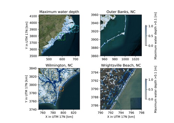
Modeled maximum water depths during Hurricane Florence (2018) for entire domain (A), with zoom at the North Carolina’ Outer Banks (B), Wilmington (C) and Wrightsville Beach (D), for minimum flood depths of 0.1 m and for areas above 0 m+NAVD88 only.
References
Leijnse T, van Ormondt M, Nederhoff K, van Dongeren A (2021) Modeling compound flooding in coastal systems using a computationally efficient reduced-physics solver: In-cluding fluvial, pluvial, tidal, wind- and wave-driven processes. Coastal Engineering 163:103796. https://doi.org/10.1016/j.coastaleng.2020.103796
Roelvink D, Reniers A, Van Dongeren A, Van Thiel De Vries J, McCall R, Lescinski J (2009) Modelling storm impacts on beaches, dunes and barrier islands. Coastal Engineering 56:1133–1152. https://doi.org/10.1016/j.coastaleng.2009.08.006
McCall R, Storlazzi C, Roelvink F, Pearson SG, De Goede R, Antolínez JAÁ (2024) Rapid simulation of wave runup on morphologically diverse, reef-lined coasts with the BEWARE-2 (Broad-range Estimator of Wave Attack in Reef Environments) meta-process model. Nat Hazards Earth Syst Sci 24:3597–3625. https://doi.org/10.5194/nhess-24-3597-2024
Leijnse TWB, Van Ormondt M, Van Dongeren A, Aerts JCJH, Muis S (2024) Estimating nearshore infragravity wave conditions at large spatial scales. Front Mar Sci 11:1355095. https://doi.org/10.3389/fmars.2024.1355095
Roelvink D, van Ormondt M, Reyns J, van der Lugt M (2025, in review). SnapWave: fast, implicit wave transformation from offshore to nearshore. Geoscientific Model Development.
Ruessink G, Michallet H, Bonneton P, Mouazé D, Lara JL, Silva PA, Wellens P (2013) GLOBEX: WAVE DYNAMICS ON A GENTLY SLOPING LABORATORY BEACH. Coastal Dynamics
