M. Traas1*, R. de Swart1
1 WaterProof Marine Consultancy & Services, Netherlands
* Corresponding author: meike.traas@waterproofbv.nl
Introduction
The Dutch Wadden Sea consists of several tidal inlet systems that typically feature one or several channel-shoal complexes. An example is the channel/shoal-system of the Wadden Sea located in between Schiermonnikoog and the mainland. West of Schiermonnikoog, water can enter or leave the Wadden Sea through the channels Westgat, Zoutkamperlaag and Gat van Schiermonnikoog, whilst east of Schiermonnikoog, water typically enters through the Lauwers channel with the Eilanderbalg as one of its branches near the southern shore of Schiermonnikoog. The border where the tidal currents from both sides meet is the tidal divide, which in this case separates the tidal basin of the Zoutkamperlaag in the west and the tidal basin of the Lauwers in the east.
Historic bathymetric surveys indicate a highly dynamic morphology of the tidal basins consisting of migrating channels and shoals, whilst also the tidal divide migrates through time. Schiermonnikoog expands towards the east, while the Eilanderbalg channel erodes the southern shore of the island tail. The question raises: can the eastward expansion of Schiermonnikoog continue or will the Eilanderbalg cut off the island tail? As a result, in-depth knowledge regarding the historic morphological evolution is vital for predicting the future morphologic evolution of Schiermonnikoog.
Objective and Methods
In this work, the historic morphological evolution of Schiermonnikoog and the channel-shoal system between Schiermonnikoog and the mainland has been analysed. The resulting findings have been used to provide an outlook for the expected developments in the near future. For this work, large-scale bathymetric surveys with a resolution of 20 m (availability every 1 to 4 years) were obtained from Rijkswaterstaat for the period 1970-2022. These surveys were examined through establishing morphological trends in transects and erosion-sedimentation maps through time. Based on the findings of these analyses, a prediction was made regarding the expected future trends in bed level evolution.
Results
The analyses of the historic bathymetric surveys indicate that the bed level in the study area varies between +2 m LAT and -15 m LAT. After the closure of the Lauwerszee in 1969, the channel-shoal system between Schiermonnikoog and the mainland evolved towards a new morphological equilibrium. This caused significant (eastward) migration of the tidal divide and the associated channels and shoals until the year 2000. Since 2000, the position of the tidal divide is relatively stable, whilst the channels and shoals remain dynamic.
Due to the alongshore east-west sediment transport in the North Sea, Schiermonnikoog is expanding towards the east. The Eilanderbalg has migrated eastward since 1970 due to the eastward expansion of Schiermonnikoog and its tidal divide. Depending on the location of the outer bend, the Eilanderbalg experiences northward or southward migration, see Figure 1. The northward migration of the Eilanderbalg causes erosion of the southeastern shore of Schiermonnikoog (Figure 1, transect A). Within the upcoming decades, it is expected that the Eilanderbalg will cut through the eastern island tail reducing the length of Schiermonnikoog and creating a more direct route to the North Sea. As a result, the tidal divide will likely experience westward migration.
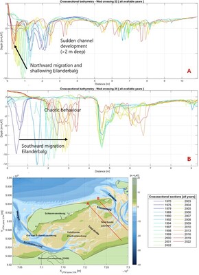
Figure 1: Historic seabed levels in the Wadden Sea area along two transects showing the morphological evolution. Cross-sections are plotted from Schiermonnikoog (0 km) to the mainland.