E. Quataert1*, M. van Ormondt2 , R. de Goede1, A. van Dongeren1,3, P. Athanasiou1, K. van Asselt1, C.M. Nederhoff2
1 Deltares, Netherlands; 2 Deltares USA, USA; 3 IHE Delft, Netherlands
* Corresponding author: Ellen.Quataert@deltares.nl
Introduction
Coastal zones are areas of high economic and ecological value which are under threat of natural hazards such as flooding and erosion. Extreme weather events like hurricanes cause loss of life, property damage, harm to the environment and disruption of local economies. Moreover, accelerated sea level rise will potentially increase intensities of extreme water levels, which will aggravate the impact of natural hazards.
It is therefore important to understand and predict the impact of these events so that authorities are able to prepare and evacuate the population. This necessitates an approach to assess flooding and damages using a forecasting system. While a number of forecasting systems are available, these usually focus on a relatively small area and a small number of hazards, mostly total water level, and rarely impacts.
The NOPP Hurricane Coastal Impacts (NHCI) project's goal is to improve our understanding of the physical processes of flood and erosion hazards and their impacts. Through ongoing research and model development, it contributes to the goal of enhancing coastal resilience against the increasing threat of extreme weather events. This presentation focusses on coastal impact forecasts, by upscaling our models to larger regions, including more physics and more impacts.
Objective and Methods
The COSMOS2 (COastal Storm MOdelling System) forecasting system covers both a large area of the US East Coast and Gulf of Mexico, and is an innovation of Barnard et al. (2014) who assessed hazards on the US West Coast. The new forecasting system is able to provide real time predictions of water levels, wave heights, flooding and morphological impact along the US coast. We use a modelling train that includes fast wave, surge and flooding models (SFINCS (Leijnse et al., 2021) and HurryWave), using forecasted COAMPS-TC wind and pressure fields. For the morphological impact prediction use more complete 2D XBeach models (Roelvink et al., 2009), with 700+ XBeach domains all along the sandy coastal areas. Computational expense of the computationally intensive 2D Xbeach models was reduced by optimizing the domain size, grid resolutions and settings as much as possible.
The forecasting system was applied, tested and continuously improved during hurricane seasons of 2022, 2023 and 2024 on the US East and Gulf of Mexico Coasts. It provided predictions of the impact of impactful Hurricanes Ian, Idalia, Lee, Ophelia, Helene and Milton.
Results
Validation of the modelled water levels and wave heights were validated by comparing with the observations at NOAA stations and deployed (drifter) wave buoys. The system was able to make an accurate forecast of the water levels and wave heights, both in terms of timing and maximum value of the high water.
Using the hydrodynamic surge and wave forcing, local 2D XBeach models are activated to predict dune erosion, overwash and breaching. To make a quick assessment of the morphological impact, the XBeach output was classified according to the Sallenger (2000) regimes of increased severity of coastal change. Figure 1 shows an example of a morphological prediction around Midnight Pass, south of Siesta Key. This former inlet has been closed for decades and re-opened during Hurricane Helene and Milton where a small shallow breach was formed, as observed in the post Milton imagery by NOAA.
In the presentation we will focus on the performance of the modelling system for the 2024 hurricanes Helene and Milton, as well as discuss the importance of taking uncertainties into account.
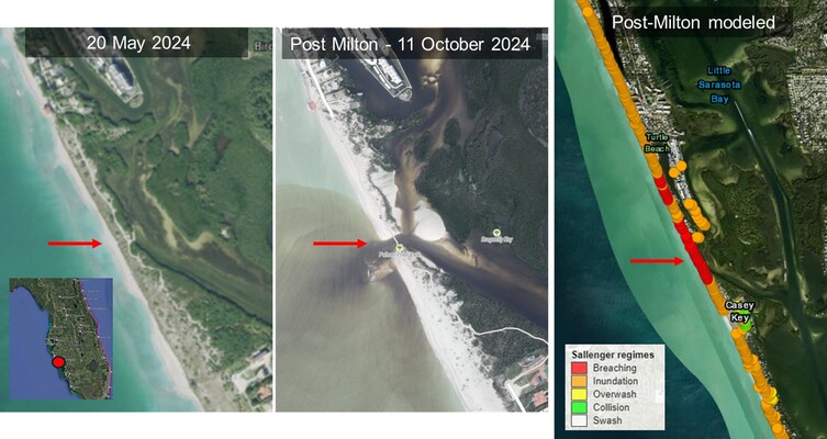
Figure 1: Pre-Helene/Milton imagery (left) and Post-Milton imagery (mid, source: NOAA) showing a small shallow breach and overwash deposits at Midnight Pass. The Xbeach model predicted breaching (right).
References
Barnard, P.L., van Ormondt, M., Erikson, L.H. et al. Development of the Coastal Storm Modeling System (CoSMoS) for predicting the impact of storms on high-energy, active-margin coasts. Nat Hazards 74, 1095–1125 (2014). https://doi.org/10.1007/s11069-014-1236-y
Leijnse, van Ormondt, Nederhoff, van Dongeren (2021). Modeling compound flooding in coastal systems using a computationally efficient reduced-physics solver: Including fluvial, pluvial, tidal, wind- and wave-driven processes. Coastal Engineering, 163, 103796. https://doi.org/10.1016/j.coastaleng.2020.103796
NHCI, https://nopphurricane.sofarocean.com/, funded by the Office of Naval Research through the National Oceanographic Partnership Program under contract N00014-21-1-2196
Roelvink, Reniers, van Dongeren, van Thiel de Vries, McCall, Lescinski (2009). Modelling storm impacts on beaches, dunes and barrier islands. Coastal Engineering, 56(11–12), 1133–1152. https://doi.org/10.1016/j.coastaleng.2009.08.006
Sallenger, A.H. Jr. “Storm Impact Scale for Barrier Islands.” Journal of Coastal Research 16, no. 3 (2000): 890–95. http://www.jstor.org/stable/4300099.
