
W.M. van Dijk1*, F. Brils2 , T. Koppenol1
1 Rijkswaterstaat Zee en Delta, Netherlands; 2 Rijkswaterstaat Water, Verkeer en Leefomgeving, Netherlands
* Corresponding author: wout.van.dijk@rws.nl
Introduction
The North Sea is a vital marine area, supporting rich biodiversity and various human activities. Sand extraction is one of them and is essential for coastal protection of the Dutch coast; however, its predicted to increase in intensity as sea-levels continues to rise, raising sustainability concerns. Sand is a finite resource, limited by the geological characteristics of extraction sites. This limitation necessitates strategic planning to manage sand reserves sustainably and minimize damage to marine habitats, particularly in ecologically sensitive areas, such as Natura 2000 sites.
Maritime Spatial Planning (MSP) aims to optimize the allocation of marine space, balancing economic needs with environmental sustainability. These plans ensure compatibility between sand extraction and other activities, such as shipping, fishing, and renewable energy development. Rijkswaterstaat, as the manager of the Dutch North Sea, prioritizes coastal resilience as well as ecological integrity. High-quality sand is selected for nourishment projects to support natural coastal processes, while avoiding or minimizing harm for the environment. By integrating ecological considerations with sustainable resource management, the aim is to balance the increasing pressures on the North Sea with the preservation of biodiversity and long-term ecosystem health.
Objective and Methods
One of our objectives is to map sand availability through a detailed geological model (build by Deltares and TNO) of the reserved area for sand (Delfstoffen Informatie Systeem, DIS). This model provides insights into sand distribution, quality, and accessibility, guiding future extraction strategies. The geological model provides first insights in the quantity of sand for the long-term, whereas it also identifies location of interest for sand extraction in the near future. For example, preparations of the Environmental Impact Assessment (EIA) 2028–2037 include identifying extraction sites that balance geological, ecological and spatial considerations. The MSP plays a crucial role in reconciling ideal theoretical scenarios with practical constraints, such as competing uses of marine space, ecological sensitivities, and logistical challenges. This presentation emphasizes the importance of integrating geology, ecological objectives into sand extraction planning to ensure practices remain sustainable for now and in the future, while addressing the growing spatial pressures in the North Sea.
Results
DIS has identified significant sand reserves within the designated reservation area, considering a depth of 12 meters. However, variations in extractable depth due to old channel remnants and heterogeneous geological deposits highlight the complexity of efficient resource utilization. Where the sand availability sometimes is high, but the need for nourishments are low. Preliminary ecological assessments, done within the Monitoring and Evaluation Program ‘Zand uit Zee’ (www.zanduitzee.nl), indicate potential impacts on marine habitats, sediment transport, and biodiversity, necessitating mitigation measures. Additional factors, such as new cable routes for offshore wind farms and expanding marine protected areas, e.g., Borkumse Stenen, further complicate spatial planning.
Critical extraction zones are identified near the southern coast of Zeeland, the port of IJmuiden, and the Wadden Islands Texel and Vlieland. Approximately 50% or even more of the reserved area overlap with competing activities, such as shipping routes, (future) energy infrastructure, and protected ecosystems. These findings underscore the need for adaptive strategies to balance sand extraction with ecological and spatial constraints. Future efforts will focus on refining extraction plans and strategies, integrating up-to-date ecological data, and ensuring alignment with evolving Maritime Spatial Plans to support sustainable resource use in the North Sea.
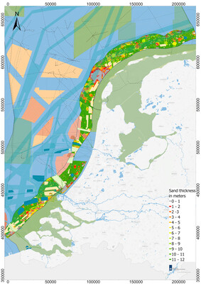
Sand thickness map overlain by other activities for the Dutch North Sea