M. Taal1*, E. Elias1, E. Quataert1, A. Van der Spek1, B. Huisman1, N. Vermeer1, Z. Wang1, L. Brakenhoff2 , Q. Lodder2, H. de Looff2
1 Deltares, the Netherlands; 2 Rijkswaterstaat-WVL, the Netherlands
* Corresponding author: marcel.taal@deltares.nl
Introduction
Dutch coastal policy aims to sustainably maintain flood protection and other functions of the coastal zone and dune areas. This is elaborated into a tactical approach and operational objectives. These have key components like ‘maintaining the coastline at its 1990 position’, ‘conserve sediments in the coastal system’ and ‘preference for soft solutions’ (see e.g. Rijkswaterstaat, 2020 and Lodder, 2024). For this it is pivotal to have insight in the needs for sand, both for the coming 15 years as well as for the longer term, with accelerated sea level rise. The knowledge development programme ‘Zandige Kust’ (Sandy Coast) was set up to improve such insights.
In the first year of the programme Deltares and Rijkswaterstaat collaborated to evaluate how much sand should be nourished, under the assumption of continuation of the present policy, should the sea level have risen with 0.5 up to 5 metres in the next one or two centuries.
Objective and Methods
For the work in the first year it was necessary to define the area that determines the position of the coastline on the long term. In other words: which parts participate in the spreading of nourished sand and should grow with the sea level. This is called the ‘active zone’ and this area needs to receive enough sediments to ‘keep up with sea level rise’ (Figure 1). The amount of sediment needed was calculated as the sum of net transports out of the area plus the product of surface area and rate of sea level rise (Taal et al., 2023).
In the next two years of the programme, much new knowledge was derived (i) on the sediment balance of the Dutch coastal system, especially since the start of the present policy (1990), (ii) on the behaviour of the deeper shoreface (bordering the coastal zone) and (iii) on the net alongshore transports in the active zone (Figure 1). This new knowledge was combined with information on nourishments since 1990 for each coastal section and all existing knowledge on the morphological behaviour.
Results
In this way the need for sediments and/or nourishments for the coming 15 years was assessed using three different calculations for each coastal section: (i) using the concept of the active zone, (ii) using the method of Rijkswaterstaat (2020) and (iii) using historical nourishment volumes. This was done for four levels in the morphological scale cascade: the individual active zone, a coastal cell, a coastal subsystem (Delta coast, Holland coast, Wadden coast) and for all coastal zones of the Netherlands together. As a whole the results were close to the calculations of Rijkswaterstaat (2020), but with reduced uncertainty and more elaboration on smaller spatial scales. This also serves other purposes, like better planning of nourishments that are not immediately needed for coastal maintenance (but serve the aim of conserving sediments in the coastal system, on each spatial scale).
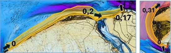
Figure 1: Transports and surface area of active zones of the coasts in the coastal cell: ‘mouth of the Eastern Scheldt’
References
Lodder, Q.J. 2024. Connecting science and policy in Dutch coastal management. The role of system understanding and conceptual models. Thesis. Technical University Delft. ISBN: 978-94-6384-581-6
Rijkswaterstaat, 2020. Kustgenese 2.0: kennis voor een veilige kust. Rapport ter onderbouwing van het beleidsadvies ‘Kustgenese 2.0’.
Taal M., Quataert, E., van der Spek, A., Huisman, B., Elias, E. Wang, Z., Vermeer, N. (2023). Sedimentbehoefte Nederlands kustsysteem bij toegenomen zeespiegelstijging. Rapportnummer: 11207897-002-ZKS-0004, Deltares, Delft.