
Martijn klein Obbink1*, Jurre de Vries1 ,Ellen Quataert2, Carlijn Meijers2
1 Rijkswaterstaat, The Netherlands; 2 Deltares, The Netherlands
* Corresponding author: Martijn.kleinobbink@rws.nl
Introduction
The Wadden Sea is highly valued for its complex dynamic nature and rich ecosystems, yet the morphological processes and interaction on different temporal and spatial scales are not yet fully understood (Oost et al., 2017). This presents challenges regarding management and maintenance practices. A better understanding of the Wadden Sea's natural dynamics can reduce anthropogenic pressures by minimizing dredging impacts, regulating salt and gas extraction, and informing policies for sustainable fishing practices. Additionally, ecological management plans, such as the Natura2000 plans, benefit from a morphological system understanding.
A way to improve decision-making in management and maintenance is through the use of conceptual models (Lodder, 2022). Conceptual models are crucial in translating detailed scientific knowledge into a comprehensive overview, thereby increasing system understanding and facilitating informed decision-making. These models also support the development of adaptive management strategies for climate change and sea-level rise. Ongoing research is essential to continuously update and refine our understanding of the Wadden Sea's natural dynamics. Our results show an update of the conceptual morphological model for the Vlie basin based on recent studies. We reflect on the relevance for Rijkswaterstaat, the organization responsible for maintenance dredging and nature conservation in the Wadden Sea.
Objective and Methods
Our case looks in more detail at the Vlie basin and refines the existing conceptual models of the Vlie inlet in the Wadden Sea. Recently, several studies have been conducted for the Vlie basin within the management and maintenance research program of Rijkswaterstaat, which together contributed to an improved system understanding on a larger scale.
We will highlight several applications of the conceptual model, focusing on areas relevant for management questions. For instance, a morphological analysis between Harlingen and the North Sea fairways identifies different causes for current increased dredging volumes. Combined with another study that investigates the abiotic effects of dredging it provides a clearer understanding of how these activities impact the ecosystem. Furthermore, studying the morphology of inlets sheds light on sediment transport and tidal dynamics. The area of channels and tidal flats in the basin, and its development over time, gives insight on trends in the tidal prism. Methods used within the studies range from analyzing bathymetric data over a decadal timescale, bathymetric data of channels with a higher spatial and temporal resolution, to the application of numerical models that analyze flow velocities and patterns.
Results
The resulting conceptual model provides insights on three temporal and spatial scales: the western Wadden Sea (large scale), the basin, and a detailed scale zooming in on areas of interest. The large scale provides boundary conditions for developments on a smaller scale, while local processes can influence large scale trends as well. The visual representation helps connect the interaction of different hydrodynamic and morphological processes. Various aspects on different spatial scales are relevant for different management questions. It is therefore essential to align the conceptual model with the questions that it should address.
Figure 1 shows the morphological changes in the Vlie basin on a decadal timescale. It gives insight into the hydrodynamic and morphological development of the channels and intertidal flats in the basin. These show processes like the migration of sandbanks in the inlet and the interaction of ebb and flood channels at local bottlenecks for channel maintenance. Our work shows that different management questions need to build on different (connected) conceptual models to identify the relevant trends and development to come up with the best management practices.
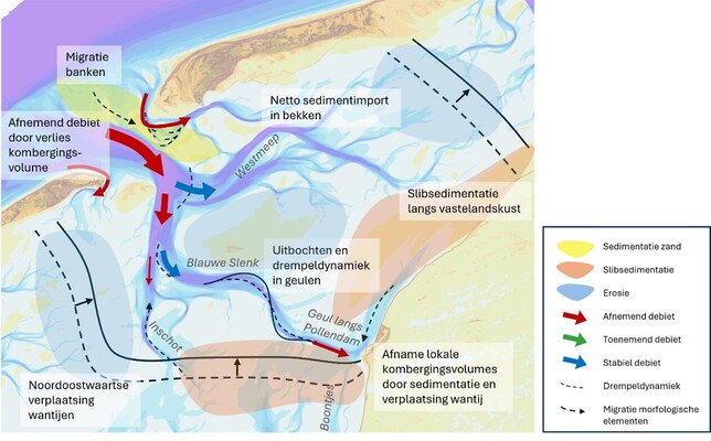
Figure 1: Development of the Vlie inlet on a timescale of decades.
References
Oost A. P., Winter C., Vos P., Bungenstock F., Schrijvershof R., Röbke B., Bartholdy J., Hofstede J., Wurpts A. & Wehrmann A. (2017) Geomorphology. In: Wadden Sea Quality Status Report. Eds.: Kloepper S. et al., Common Wadden Sea Secretariat, Wilhelmshaven, Germany. Last updated 21.12.2017. Downloaded 27.01.2025. qsr.waddensea-worldheritage.org/reports/geomorphology
Lodder, Q., & Slinger, J. (2022). The ‘Research for Policy’cycle in Dutch coastal flood risk management: the Coastal Genesis 2 research programme. Ocean & Coastal Management, 219, 106066.