M. Groeneboer1*, J.H. Nienhuis1 , M. vd Vegt1, R.S.W. vd Wal1
1 Utrecht University, Netherlands
* m.groeneboer@students.uu.nl
Introduction
Barrier islands are dynamic systems with active morphodynamics. On The Boschplaat, the tail of the island Terschelling, these dynamics disappeared since the creation of a sand drift dike in the 1930s and 1980s (OBN Deskundigenteam Duin- en Kustlandschap, 2018). This dike prevents sediments from the North Sea to deposit on parts of the tail, resulting in a stagnant salt marsh with low biodiversity and a high risk of drowning with sea level rise (OBN, 2018 and SBB, 2018). To address this, a plan has been developed to create an artificial overwash by making a gap in the dike and reintroduce sediment dynamics. However, no studies have yet been conducted on the long-term developments of such a washover complex. Will the gap expand or silt in? And how long will this process take? This study aims to resolve this knowledge gap by simulating the washover development over the next 25 years.
Objective and Methods
We set up a Delft3D FLOW + SWAN model to simulate washover morphodynamics during storms (see also Tavill, 2024). We couple this model with a Matlab-routine that simulates dune development in the intermediate (non-stormy) parts of the year. The initial bathymetry is based on AHN4 (lidar) and Vaklodingen (jarkus) data, and adjusted to create a 500-meter-wide overwash between beach poles 24.20 and 24.80. The hydrodynamic boundary conditions for 6 storm scenarios were selected based on the model output of Lenstra et al (2019). Each of these 6 storms are simulated every 5 years, then morpodynamically corrected for their recurrence time, and finally summed linearly to obtain a representative 5-yearly effect of storms. During quiet periods in between storms, a simple dune model is implemented to grow dunes from the yearly aeolian sediment input, as defined by Keijsers et al. (2014), across the washover area.
This cycle is repeated every 5 years to simulate 25-year morphologic development.
Results
We find that the resulting morphology is a balance between aeolian sand input and storm erosion. Sand available for dune building is approximately 13 /m/yr, whereas storm erosion equals 67 /m/yr for an overwash with an initially constructed gap height of +1.7m NAP (Fig. 1).
We also find that most erosion occurs within the washover gap created in the dike (Fig. 1b). Landward of this gap, deposited sediments form a washover complex. The spatial erosion pattern inside the washover gap likely indicates the onset of channel formation. Channels were observed to form in wide washovers by Tavill (2024). Similarities in erosive patterns are observed across different washover heights.
The morphologic effect did not vary significantly between the 6 storm classes: smaller waves seem to be as important as higher waves for yearly erosive patterns when their frequency is considered. This is consistent with findings of Wesselman (2020) on washover dynamics.
Finally, we wish to highlight the importance of evaluating the long-term accretionary processes, such as dune building, alongside long-term erosional processes caused by storms and, if the washover gets eroded to lower elevations, potentially tides. These processes must be in balance to maximize the lifespan of this constructed overwash gap.
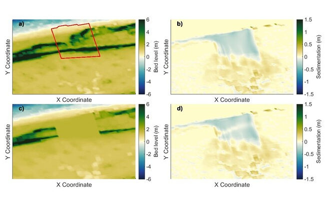
Original bed level of the overwash area (a); bed level after digging out an overwash extending down to + 1.7m NAP (c); bed level change after one year of storm erosion (b), bed level change after one year of storm erosion and dune growth (d).
References
Keijsers, J. G. S., Poortinga, A., Riksen, M. J. P. M., & Maroulis, J. (2014). Spatio-temporal variability in accretion and erosion of coastal foredunes in the Netherlands: Regional climate and local topography. PLOS ONE, 9(3), e91115. https://doi.org/10.1371/journal.pone.0091115.
Lenstra, K. J. H., Pluis, S. R. P. M., Ridderinkhof, W., Ruessink, G., & van der Vegt, M. (2019). Cyclic channel-shoal dynamics at the Ameland inlet: The impact on waves, tides, and sediment transport. Ocean Dynamics, 69(4), 409–425. https://doi.org/10.1007/s10236-019-01249-3.
OBN Deskundigenteam Duin- en Kustlandschap. (2018). Natuurherstel door dynamisering op de Boschplaat (by A. P. Oost, T. V.d. Heide, O. Esselink, & E. J. Lammerts; Advies OBN-16-DK). Vereniging van Bos- en Natuurterreineigenaren. Consulted on 24-01-2024, from: https://www.natuurkennis.nl/Uploaded_files/Publicaties/obn-advies-natuurherstel-door-dynamisering-van-de-boschplaat-def-2.ba8e66.pdf.
Staatsbosbeheer. (2018). Boschplaat 2050: Natuurlijke eiland-staart van formaat; Veilig voor mens, plant en dier. Staatsbosbeheer. Retrieved from www.boschplaatvisie.nl.
Tavill, E. (2024). Modelling the morphological effect of artificial washover width on Terschelling during storm conditions (Master's thesis). Utrecht University.
Wesselman, D., de Winter, R., Engelstad, A., McCall, R., van Dongeren, A., Hoekstra, P., ... & van der Vegt, M. (2018). The effect of tides and storms on the sediment transport across a Dutch barrier island. Earth Surface Processes and Landforms, 43(3), 579-592.
