A.J. Timmer1*, J.B. Woerdman2 , A.W. Minns2 , P.F.V.W. Frankemölle1 , J.J. van der Werf1
1 University of Twente, The Netherlands; 2 Royal HaskoningDHV, The Netherlands
* Corresponding author: a.j.timmer@student.utwente.nl
Introduction
Coastal regions are one of the most densely populated areas on the world, which are under threat of climate change-induced coastal erosion. This risk is particularly pronounced in less developed countries, which lack the resources to manage such risks, leaving poor communities disproportionally affected.
To deal with coastal erosion, hydro- and morphodynamic models have become an indispensable tool for gaining insights into nearshore hydro- and morphodynamics. However, these models rely heavily on expensive in-situ bathymetry data. This data is often unavailable in less developed countries, such as in data-poor regions like West-Africa, limiting effective coastal erosion management in these regions. To address this data scarcity, Satellite Derived Bathymetry (SDB) offers an innovative solution by using satellites to collect bathymetry data. High resolution, open-access satellites (Sentinel-2 and ICESat-2) offer unprecedented spatio-temporal data coverage. This could transform coastal sciences from a data-poor field into a data-rich field.
One of the West-African nations that can profit from SDB is The Gambia. Coastal erosion poses a direct threat to its vital tourism sector, which is situated predominantly along a fast-eroding coast. SDB has the potential to fill bathymetry data gaps, which in turn can help reduce the impact of coastal erosion in The Gambia.
Objective and Methods
The objective of this study is to determine the applicability of open-access SDB in hydro- and morphodynamic modelling in data-scarce regions. To reach this goal, two SDB methods will be used: the wave kinematics method4, and the empirical method. The wave kinematics relies on deriving wave celerity from satellite images, and translating this to water depth, using the linear dispersion relationship of waves. The empirical method builds on the principle that light intensities are scattered and absorbed by water, establishing a relationship between the depth of the water column, and the measured reflected light.
The first step of the study is to compare the two SDBs with in-situ bathymetry. This will include a sensitivity analysis into the effect of important factors such as turbidity and wave action intensity. The second step is implementing these SDBs into an existing Delft3D model of The Gambia’s coast. The model output of both nearshore currents, and bed shear stresses, will be compared with the original model (based on in-situ bathymetry measurements), to assess the applicability of SDB for nearshore hydro- and morphodynamic computations.
Results
Although this study has just started, it is expected to provide valuable insights into the performance of SDB methods in shallow coastal environments. During literature research, two state-of-art methods, that offer large spatial coverage, were identified. The wave kinematics method shows worse RMSE values (compared to in-situ bathy), but its computation times are much shorter. The empirical method must deal with light attenuation, of which turbidity poses the most significant problem, increasing computation time and limiting the water depth it can be applied to. However, it does show better statistical performance, with lower RMSE values.
There is little research on implementing SDB in hydro- and morphodynamic modelling. Therefore, the applicability of doing so is largely unknown. This study’s findings could pave the way for broader SDB applications in coastal management projects.
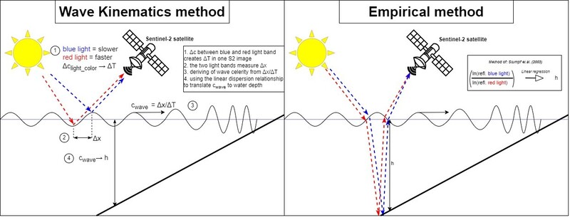
Schema of the two main SDB method: the sea surface sensing Wave Kinematics method, and the sea bed sensing Empirical method
References
Rafael Almar, Erwin W.J. Bergsma, Gregoire Thoumyre, Lemai Chenevier Solange, Sophie Loyer,
Stephanie Artigues, Gregoire Salles, Thierry Garlan, and Anne Lifermann, (2024), Satellite-derived
bathymetry from correlation of Sentinel-2 spectral bands to derive wave kinematics: Qualification
of Sentinel-2 S2Shores estimates with hydrographic standards. Coastal Engineering, 189.
Christopher Daly, Wassim Baba, Erwin Bergsma, Gregoire Thoumyre, Rafael Almar, and Thierry
Garlan, (2024), The new era of regional coastal bathymetry from space: A showcase for West Africa
using optical Sentinel-2 imagery. Remote Sensing of Environment, 278.
International Hydrographic Organization (IHO), (2024), International Hydrographic Organization Guidance to Satellite-Derived Bathymetry.
Massimo Bernardis, Roberto Nardini, Lorenza Apicella, Maurizio Demarte, Matteo Guideri, Bianca
Federici, Alfonso Quarati, Monica De Martino, (2023), Use of ICEsat-2 and Sentinel-2 Open Data
for the Derivation of Bathymetry in Shallow Waters: Case Studies in Sardinia and in the Venice
Lagoon. Remote Sensing, 15.
Matthijs Gawehn, Rafael Almar, Erwin W.J. Bergsma, Sierd de Vries, Stefan Aarninkhof, (2022), Depth Inversion from Wave Frequencies in Temporally Augmented Satellite Video. Remote Sensing, 14.
